I really like GIS. AND I really like teaching GIS; you know, the theory and concepts and ideas that are transferable to a variety of desktop/web-based tools. So why wouldn't I be excited for NEARC's annual GIS Educators Day? Well... I am in spirit but not in practice and this post is meant to serve as a warning to folks who can't read between the lines in the proposal criteria (I certainly couldn't last year).
My peeve is with this language (unchanged from last year):
I understand the acronym stands for Northeast Arc User. I understand that it is sponsored by ESRI. I don't understand why the language wasn't changed this year to reflect criteria and better guide proposal submissions that aren't listed online and only discovered via email:
Apparently allowing students to explore a variety of web-based mapping tools (yes, including ArcGIS Online) and asking them to compare and contrast their functionality doesn't count as 'education' and all you folks teaching non-ESRI products aren't really GIS Educators. As I've mentioned in previous posts, I use ArcMap on a daily basis - I have no issue with ESRI's products per se, I do have an issue with hiding criteria that require presenters to explicitly use or integrate a specific software package under the umbrella of GIS Education. I'll refer you to this sarcastic rant for my reasoning. From my perspective, this is less about exploring education and instead co-opting the language of GIS Education (making that acronym synonymous with one vendor) to ensure everyone is drinking the same Kool-Aid. So to all you wanna-be presenters - make sure you're teaching GIS correctly before you go submitting any proposals..
My peeve is with this language (unchanged from last year):
"GIS Educators Day, sponsored by NEARC and Esri, is a full-day conference devoted exclusively to topics and issues pertaining to the use of GIS and other geospatial technologies in K-12, college, and informal education."
I understand the acronym stands for Northeast Arc User. I understand that it is sponsored by ESRI. I don't understand why the language wasn't changed this year to reflect criteria and better guide proposal submissions that aren't listed online and only discovered via email:
 |
| Response To Proposal |
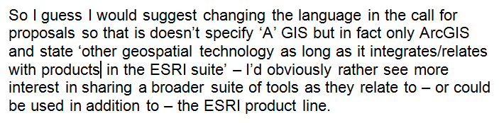 |
| My Suggestion |
Apparently allowing students to explore a variety of web-based mapping tools (yes, including ArcGIS Online) and asking them to compare and contrast their functionality doesn't count as 'education' and all you folks teaching non-ESRI products aren't really GIS Educators. As I've mentioned in previous posts, I use ArcMap on a daily basis - I have no issue with ESRI's products per se, I do have an issue with hiding criteria that require presenters to explicitly use or integrate a specific software package under the umbrella of GIS Education. I'll refer you to this sarcastic rant for my reasoning. From my perspective, this is less about exploring education and instead co-opting the language of GIS Education (making that acronym synonymous with one vendor) to ensure everyone is drinking the same Kool-Aid. So to all you wanna-be presenters - make sure you're teaching GIS correctly before you go submitting any proposals..